Well, the riding has been slim.
Two months ago I printed out a map I made of the gravel roads in Weld county, conveniently color-coding the different road surfaces. I printed it out on my black-and-white laser printer for a ride around Lower Latham Reservoir I never got around to doing. I assume I was planning to highlight the route with a pen.
Two weeks ago I finally got around to doing that ride. Looking at the map it looked like I could make out which roads were gravel by the thickness of the lines and shades of grey. So I threw it it my jersey pocket and headed down the hill on my usual route. Turning left onto the first gravel road I was surprised when my front wheel washed out and I almost crashed. The roads were already dry and sandy and it was only March!
Merging back on to Highway 60 I followed it south heading for County Road 46, which was supposed to be dirt. Just after CR 44 the shoulder disappeared, so I turned around to take CR 44 east a mile to CR 29 which would take me south to CR 46. According to my map, CR 44 was also supposed to be dirt, but it turned out to be paved. Strange. The map also showed CR 42 to be dirt, so when I reached CR 29 I decided to head back north to try it out. CR 29 was dirt and that agreed with the map, so I figured maybe the road was paved since the mapping data was made. Reaching CR 42, it turned out to be paved, so I turned around and backtracked to CR 46. It was paved too! Hmm, maybe this map didn’t print out like it should have.

Original map (left), Carto-Fail(TM) (right)
I zig-zagged northeast on the section lines, hitting some dirt on CR 36 and some pavement on CR 46 until I reached Highway 85. Crossing over put me back on the dirt.
Riding along CR 46 I noticed some extension cords running along the road. I figured they were being used for running irrigation pumps or something. There’s a little jog north on CR 37 you have to take before getting back on CR 46. There were some cows at a farm that I initially thought were steers, then I saw udders, so I paid a bit more attention to them (working in the dairy industry). Then I saw something else hanging from a cow – oh my! That’s a calf! I stopped to watch the calf be born. Initially it hit the ground like a sack of potatoes and laid there. Mom licked the calf from one end to the other but it still laid there limp. I silently cheered the little guy on. After another minute of licking, I saw a leg give a little kick and soon the calf was sitting up. Since the show was over, I continued east on CR 46.

A little further down the road I met a big friendly dog and stopped to give him a scritchscratch. Going farther I saw more extension cords running alongside even more extension cords. Visually following them I finally saw them connected to a black box, and stopping to take a closer look I found it was labeled “Seismic Test Equipment”. Ah, welcome to the Colorado Oil and Gas Boom. Come for the drilling and stay for the fracking.
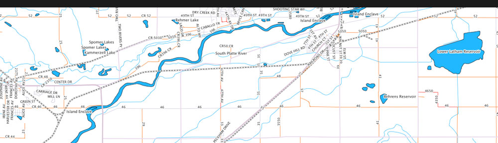
At CR 43 you have to make another jog north onto CR 46 1/2 which takes you back to CR 46. At CR 47 you can finally turn north (odd numbers go north-south, evens east-west, and the roads numbers increment by two every section (one mile)). This road rolls up and around Lower Latham Reservoir. It’s a nice road – well worth working into a gravel route in these parts. It eventually turns to pavement and you’re treating to a nice descent down to Highway 34. From there I took Business 34 and some backroads back into Evans. Riding by the first subdivision, I spotted a man pushing a palleta cart – WOOT. $1.50 later I had a coconut palleta and everything was good.
Fast forward a week and I was ready to check out some more gravel roads around Milliken and Johnstown. This time I made a map with symbology designed to work on my black and white printer. I started out on the same route down to Highway 60, but took it west into Milliken instead. I turned south onto the gravel at CR 25 and took it south to another section of CR 46. Here it was dirt but looked like it had been recently oiled or something. From 46 I turned south on CR 21 which climbs up a bit and then turns west and becomes CR 42. After a few miles I turned north on CR 15 which drops you down a good hill and right at the bottom you have to make a hard left onto CR 44 to stay on the gravel.

CR 46
CR 44 turns into pavement at Colorado Blvd., so I turned north and rode the asphalt north through Johnstown. It jogs west at CR 50 and climbs a bit past a large dairy with hundreds of Holsteins. It then turns to dirt. At CR 52, the route I was supposed to take back east towards home, a sign said the road was closed for bridge construction. Luckily, the detour was on the conveniently placed CR 52 1/4, just a quarter mile north. It a nice road, looping around back to CR 52 and was worth the detour. Another half mile ran into yet another CartoFail. Zoomed out, it looks like CR 52 continues east uninterrupted. In reality, and obvious if you zoom in, there’s a bridge missing.

Oops
I had to detour south a bit a CR 15 1/2 to CR 50 and back north on CR 17 to get back to CR 52. It was worth it though – CR 52 is nice gravel and it rolls its way up back to CR 25, which took me back home.

On the way I decided I was going to sell my Bont MTB shoes. I had been looking for a light, super stiff shoe that would work with my Time ATAC pedals. I also own a set of Bont speedskating boots, so when I saw these shoes on eBay I had to try them. But even though they’re totally heat-moldable, I couldn’t get them to be comfortable. They work great for me on the skates, but when skating my weight is more on my heel. When switched to being on the ball of my foot they just didn’t work. So if anyone wants the ulitimate gravel shoes – check my listing on eBay.
